

Rides We Like: Rehoboth Beach Circumnavigating Rehoboth Bay
(2016) Despite returning year after year to Rehoboth Beach, Delaware, I always find new experiences that surprise me. Strangely enough a new experience extended from the curiosity to visit an old route. It circumnavigates around both Rehoboth and Indian River Bays.
As all Rehoboth Beach rides start I pointed myself south on the Coastal Highway/ Route 1. To access the variation points on this route, I had to pass through the town of Dewey Beach, Delaware. This stretch of road is jerky with several red lights, but most of the time they are in the favor of the traveler. The excitement begins to build as the last stoplight is cleared, and the route enters the slivered Delaware Seashore State Park. To the left is the Atlantic Ocean. To the right is always Rehoboth Bay.
Despite its droning straightness, despite its variable headwind, despite the ever-distant bridge forever seeming five miles beyond, I do enjoy seeing the native osprey population in action along this stretch. These birds of prey initially had me confused with eagles. They are black and white and are similar in size to eagles. To watch them lift off from manmade nests (feature photo) with lumbering giant wings is a beautiful sight. To see their tactical return flights to the nest with fish onboard, constantly tacking into the headwind is an easy distraction from the mundane for a cyclist looking for challenges. My main bewilderment came in wondering why the power company erected high-tension lines between the osprey nests and the ocean. The powerful birds must negotiate these lines every time they go on the hunt. Sadly I have seen osprey casualties on these lines.
Moving on to the end of Delaware Seashore Park and the new Indian River Bridge stands in the way of each rider. It’s what provides 35 feet of climbing to any ride by going over it once. The tall spots in Delaware must be manmade. (Delaware's Ebright Azimuth is beleived to be the highest point in the state at 448 feet above sea level. This elevation can be found just over the Pennsylvania border.) By the way, the Indian River Bridge has about fifteen Strava segments attached to it. One part I forgot to mention is the fact that the entire ride to the point has been in a comfortably wide bike lane.

The out-of-control ride elevation profile from Thursday's ride. The lowest value is zero feet of sea level. The middle is 25 feet. Laughably the top value is fifty feet.
The turn onto Garfield Parkway can be easily remembered by the Huey Helicopter on a stand as one passes a military installation. A new experience was waiting for me as I turned onto the parkway in the form of recent road construction. This used to be a double-wide lane for motorists. Now it was being resurfaced and down to one lane with a dedicated bike lane. Delaware is becoming a cycling destination.
I must point out I was nervous through here. I targeted to ride on this particular day because it wasn’t forecasted to climb above 90 degrees. But as I rolled toward the town of Millville, the road was extremely sticky and clinking chunks of asphalt cracked off my frame. Further concern was the build up of asphalt on the Vittoria Corsas. I felt like today was the day the Corsas would quit. They didn’t; I had safe passage through the eight- mile construction zone. I made it safely through Millville and Clarksville. I rolled easily into Dagsboro after pulling over to wipe the tires clear of debris.
Immediately after clearing through Dagsboro the route of old turned onto Iron Branch Road. It too continued the bike lane. How exciting to ride in my own lane. Strangely I saw no other cyclists after leaving Route 1 to this point. I did see two boys staring into their phones on bikes on the shoulder. Probably playing Pokemon Go. They did wave though. I was also getting excited for one of my sightseeing stops. Unfortunately, though, it seems Vlasic pickles sold their plant. A tiny “For Sale” sign out front eclipsed two giant vats. Sadly I decided to roll on without snapping a photo.
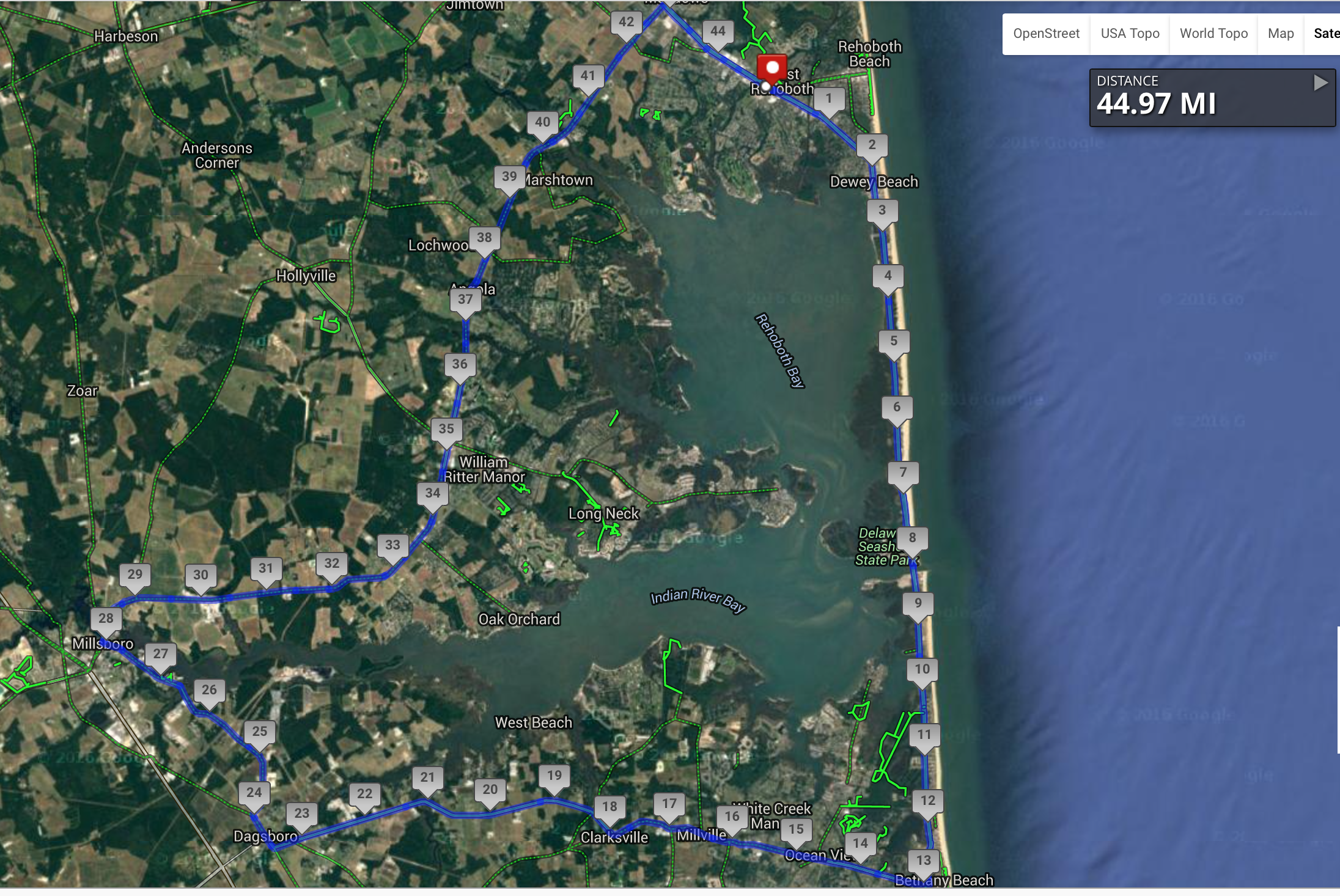
The loose course map with satellite view takes the rider south before turning west. The long road from mile marker 29 to 42 is John J. Williams Highway.
Making a right again on another Main Street, this time in the small town of Millsboro, I geared up for the longest stretch of the entire route. There are two sights on John J. Williams Highway. I was greeted with a few other signs.
Years ago, the Missus and I honeymooned in Montana between Christmas and after New Year’s. To get from the airport in Bozeman to Big Sky, we had to take a road through ‘The Canyon’ as people called it. It was recommended we did it before the sun went down. We found out why as we took it during sunset. There were scores of white crosses marking locations where motorists lost a life. While there aren’t scores of crosses on John J. Williams Highway, there are enough to contemplate what happens on this road. I would estimate I saw markers of at least a dozen casualties, many of them DUI related.
The last time I rolled through here, I remember a massive agriculture plant with signs instructing truck drivers to never get out of their trucks. I rolled through this plant again noticing signs saying it was receiving grain today. The price was announced on a board at the entrance. The plant is massive, which is why I couldn’t get a photograph of it. Also, this is where the bike lane is combined with rumble strips. It’s also where the bike lane is remarkably thin. Trucks. Thin bike lane. Rumble strips. Signs ordering truckers to stay in the cab. It wasn’t worth it to stop.
This nearly fifteen-mile experience disrupts one difficult side effect of this ride. For brief moments on the highway, there are actual moments of shade. Here a grove of trees, there two long segments of reprieve from the hard sun. It’s also where the wind began to kick up. There may be no climbing, but this route will wear one down in other ways.
I finally saw a remarkable bridge, one of my sought after sights, after exploding out of the last bits of shade. It is a wonderfully crafted wooden bridge spanning the road. I had entered one of the most impressive golf courses I had ever seen. Don’t take it from me, as I am not a golfer, but I am quite impressed by the water hazards having sand beaches. The greens were also remarkably lush for an area as sandy and parched as this. I snapped a photo and downed my only Untapped gel. I checked my GPS to see disbelieving length still remaining on this road.

The golf cart bridge that crosses John J. Willams Highway. This also shows just how much space the bike lane grants.
I powered through the final miles as the stoplights became regular. I was still in my own bike lane. There was a regularity of strips malls now. I thought, “I must be getting close to Route 1.” I was nearly home. A couple of miles later and I saw the crowded Coastal Highway. But again it has its own bike lane, albeit shared by buses.
Speaking of the lane along the Coastal Highway, it was satisfying to pass hundreds of cars stuck in the miles-long traffic jam. A couple of flicks of the handlebars onto back roads and I snuck around the heavy traffic.
Laughingly my ride had an elevation gain of only 35 feet. I suppose that’s what happens when riding at a beach town. It’s also laughable considering those 35 feet came by crossing the bridge. This ride was much more challenging than that though. I think this ride could be extremely challenging on a track bike with the correct gearing. Being dead flat means there’s little chance of coasting.
I returned home just shy of fifty miles. I had made a few wrong turns, and the development navigations were left off the featured map. Should riders find themselves getting bored with the typical south on Route 1, U-turn, and subsequent return north via Route 1, this route is certainly a worth consideration. If I had to put a distance on just how far I rode without a bike lane, I would say it was a matter of meters. Percentage-wise it would certainly be less than 1% of the route. Take a track bike, take a time trial bike, take any old bike and rip it around Rehoboth Bay, it's worth it to see the back towns and back roads of Delaware's beach communities.

